Introduction
This is a digital version of the Quaternary Geology of Wisconsin, a map of sediment deposited by glaciers, streams, wind, and other processes during the Quaternary Period (2.58 million years ago to present).
This digital version of the publication can be accessed by screen-reader, including the map geography, and can be fully navigated using a keyboard.
Skip directly to mapTable of Contents
Publication Information
Authors
J. Elmo Rawling III, Eric C. Carson, John W. Attig, David M. Mickelson, William N. Mode, Mark D. Johnson, and Kent M. Syverson. Cartography by Caroline Rose.
Publication number and date
Map 512, 2025
Scale and Projection
Scale is 1 to 500,000. Wisconsin Transverse Mercator Projection, 1991 adjustment to the North American Datum of 1983 (NAD 83/91).
Acknowledgements
The authors dedicate this map to Lee Clayton, Tom Hooyer, WGNHS staff, colleagues, and students who worked to develop the mapping strategy for Quaternary sediment and landforms in Wisconsin. Kacie C. Stolzman, G.E. Graham, and Elizabeth G. Ceperley helped prepare the map, and comments from three peer reviewers improved the final product. Funding was provided by the National Cooperative Geologic Mapping Program of the U.S. Geological Survey, under Cooperative Agreement G20AC00201, and the Wisconsin Geological and Natural History Survey. The views and conclusions contained in this document are those of the authors and should not be interpreted as necessarily representing the official policies, either expressed or implied, of the U.S. Government.
Publisher Information
Wisconsin Geological and Natural History Survey. Division of Extension, University of Wisconsin-Madison. Susan K. Swanson, Director and State Geologist. 3817 Mineral Point Road, Madison, Wisconsin 53705-5100. (608) 262-1705. wgnhs.wisc.edu
GIS files and a georeferenced PDF of this publication can be found at https://doi.org/10.54915/xqpw9883.
Suggested Citation
Rawling, J.E., III, Carson, E.C., Attig, J.W., Mickelson, D.M., Mode, W.N., Johnson, M.D., and Syverson, K.M., 2025, Quaternary geology of Wisconsin: Wisconsin Geological and Natural History Survey Map 512, 1 pl., scale 1:500,000, https://doi.org/10.54915/xqpw9883.
Digital version
This digital, accessible version of the Quaternary Geology of Wisconsin was created by Caroline Rose with accessible maps by XR Navigation using the Audiom mapping platform and accessible charts by Frank Elavsky using the Data Navigator library.
Support for this work was provided by the University of Wisconsin - Madison Division of Extension with funding from the Innovation Grant Program.
Map
Map Symbols
For geologic map units, please see section "Explanation of Map Units" below.Geologic point and line symbols
- Geologic contacts (uncertain contacts between units rb and ru are not shown as lines; a dot pattern differentiates these units.)
- Subglacial meltwater flow direction indicated by eskers
- Ice flow direction indicated by drumlins and other streamlined landforms
- Meltwater flow direction indicated by general slope and relict channels
- Wind direction indicated by dunes
- Spillway flow direction from major proglacial lakes
Reference Layers
- Ice Age National Scenic Trail
- North Country National Scenic Trail
- Selected highways
- County and tribal seats
- Tribal land areas (including reservations, communities, and trust lands)
- Ceded territory boundaries of 1837 and 1842
- County boundaries
- Selected rivers
- Selected waterbodies
Explanation of Map Units
Map Unit Descriptions
Glacial Sediment of the Miller Creek Formation
Reddish-brown clay-rich till and similar sediment deposited by the Superior Lobe late in the Wisconsin Glaciation.
Unit Ep:
Wave-washed plains with localized offshore lake sediment over till, especially where adjacent to nearshore proglacial lake sediment (ln). Includes areas modified by nearshore processes in proglacial lakes (typically wave-cut benches) where there are minor amounts of sandy nearshore sediment.
Glacial sediment of the Trade River Formation
Brown to yellowish-brown silty-clay till and similar sediment deposited by the Grantsburg Sublobe that advanced from the southwest late in the Wisconsin Glaciation.
Unit Tm:
Areas of rolling topography in moraines.
Unit Th:
Areas of hummocky topography with typically 10 m of relief.
Glacial sediment of the Kewaunee Formation
Reddish-brown to brown silty-clay till and similar sediment deposited by the Green Bay and Lake Michigan lobes late in the Wisconsin Glaciation.
Unit Km:
Areas of hummocky topography with typically less than 10 m of relief in moraines.
Unit Kh:
Areas of hummocky topography with typically 7 m of relief not in moraines. Typically draped over older sediment.
Unit Ks:
Areas of drumlins and other streamlined landforms. Drumlins with older till or sand and sandy gravel in the core are common.
Unit Kr:
Areas of gently rolling topography.
Unit Kp:
Areas of wave-washed plains with localized lake sediment over till.
Unit Kb:
Areas where glacial sediment is thin and topography is controlled by underlying bedrock.
Glacial sediment of the Oak Creek Formation
Gray to yellowish-brown silty-clay till and similar sediment deposited by the Lake Michigan Lobe late in the Wisconsin Glaciation.
Unit Om:
Areas of hummocky topography with typically 3 m of relief in moraines.
Unit Oh:
Areas of hummocky topography with typically 5 m of relief not in moraines.
Unit Os:
Areas of drumlins and other streamlined landforms.
Unit Or:
Areas of gently rolling topography.
Unit Op:
Areas of wave-washed plain with localized thin lake sediment over till.
Glacial sediment of the Holy Hill Formation
Brown to yellowish-brown sandy till and similar sediment deposited by the Green Bay and Lake Michigan Lobes late in the Wisconsin Glaciation.
Unit Hm:
Areas of hummocky topography with typically 10 m of relief in moraines. Contains areas of sandy and gravelly outwash. Few isolated ice-walled lake plains.
Unit Hh:
Similar to Hm but not in moraines and meltwater-stream sediment is common (su and sc).
Unit Hl:
Hummocky topography with typically less than 3 m of relief.
Unit Hs:
Areas of drumlins and other streamlined landforms.
Unit Hr:
Areas of gently rolling topography.
Unit Hb:
Areas where glacial sediment is thin, and topography is controlled by underlying bedrock.
Glacial sediment of the Copper Falls Formation
Reddish-brown to brown sandy till and similar sediment deposited by the Langlade, Wisconsin Valley, Chippewa, Superior, and Ontonagon lobes late in the Wisconsin Glaciation.
Unit Ch:
Areas of hummocky topography with typically 30 m of relief. Contains areas of sandy and gravelly outwash and sandy and silty lake sediment. Ice-walled lake plains are common.
Unit Cl:
Similar to Ch but with typically 10 m of relief.
Unit Ci:
Poorly sorted sandy and gravelly sediment in the ice-proximal parts of outwash plains and fans. May contain some till.
Unit Cm:
Moraines or narrow zones of boulder ridges and ice-walled lake plains that mark former ice-margin positions.
Unit Cs:
Areas of drumlins and other streamlined landforms.
Unit Cr:
Areas of gently rolling topography. Southernmost extent includes areas that predates the late Wisconsin Glaciation.
Unit Cb:
Areas where glacial sediment is thin and topography is controlled by underlying bedrock.
Glacial sediment of the River Falls Formation
Reddish-brown sandy till deposited by glaciers that advanced into the area from the Superior basin during the Illinoian Glaciation.
Unit Rr:
Areas of gently rolling topography. Glacial landforms are absent, and most sediment is preserved on uplands. Some meltwater-stream sediment is present.
Glacial sediment of the Zenda Formation
Brown to pink silty-clay till and similar sediment deposited by glaciers that advanced into the area from the Lake Michigan basin during the Illinoian Glaciation.
Unit Zh:
Areas of hummocky topography with typically 6 m of relief.
Glacial sediment of the Walworth Formation
Brown silty-clay till and similar sediment deposited by glaciers that advanced into the area from the Lake Michigan basin during the Illinoian Glaciation.
Unit Ws:
Areas of drumlins and other streamlined landforms.
Unit We:
Eroded areas with a dendritic drainage network and no glacial landforms. Typically includes ru on slopes.
Glacial sediment of the Marathon Formation
Brown to gray silty till and similar sediment deposited by glaciers that advanced into the area from the northwest prior to the Illinoian Glaciation.
Unit Mr:
Areas of very gently rolling topography. Glacial landforms are absent. Was likely continuous further to the east and south before removal by erosion, as evidenced by small outliers.
Glacial sediment of the Pierce Formation
Dark gray to yellowish-brown loam till deposited by glaciers that advanced into the area from the northwest prior to the Illinoian Glaciation.
Unit Pe:
Eroded areas with a dendritic drainage network and no glacial landforms. Typically includes ru on slopes.
Organic-rich sediment
Unit o:
Organic-rich sediment in marshes and other wetlands. Flat to low-relief surfaces in wet areas. Typically overlies sediment found in adjacent map units and lake sediment.
Modern and premodern nonglacial stream sediment
Stratified sand and silt in modern floodplains and in terraces containing premodern nonglacial sediment.
Unit sm:
Adjacent to modern streams, deposited during the Holocene.
Unit sn:
Premodern, non-glacial, graded to alluvial terraces and streams, deposited during the Pleistocene.
Windblown sediment
Stratified and well-sorted sand or massive silt deposited by wind.
Unit wa:
Sand deposited in low-relief sheets and dunes with up to 15 m of relief, typically cross bedded. Commonly associated with extensive outwash and lake plains.
Unit wi:
Massive silt deposited as loess, thickest adjacent to the Mississippi River and thinning eastward.
Unit wt:
Massive silt deposited as loess in the Wisconsin Glaciation over glacial sediment that was deposited prior to the Illinoian Glaciation.
Lake sediment
Stratified and well-sorted sandy gravel, sand, silt, and clay deposited in lakes.
Unit lp:
Lake plains formed in ice-marginal lakes, includes both laminated offshore and bedded nearshore sediment. Includes small hills that were islands within the lakes.
Unit ln:
Deposited along shorelines of the Great Lakes and ice-marginal lakes; includes dunes, wave-cut benches, sand bars, spits, and offshore plains.
Meltwater-stream sediment in outwash plains and fans
Stratified sandy gravel, gravelly sand, sand, and silt, typically cross bedded, deposited by glacial meltwater streams in low-relief outwash plains and fans. Abandoned anastomosing channels are identifiable in many places. Closed depressions located where buried ice melted out.
Unit su:
Original depositional surface is recognizable in most places and outwash stream channels are recognizable in many places.
Unit sc:
Deposited on stagnant glacial ice, original depositional surface is pitted or not recognizable in most places as a result of subsequent collapse. Topographic relief is variable.
Unit sh:
Mixed with debris flows and till in areas of hummocky topography.
Unit se:
Occurs on dissected uplands and likely formed during the glaciation that deposited the River Falls Formation.
Meltwater-stream and related sediment in the Kettle Moraine
Stratified sandy gravel, gravelly sand, sand, and silt, typically cross bedded, deposited by glacial meltwater streams in the Kettle Moraine. Sediment deposited by the Lake Michigan and Green Bay Lobes during the glacial advance that deposited the Holy Hill Formation.
Unit kmh:
Areas with generally hummocky topography with typically 25 m of relief.
Unit kmc:
Areas with pitted surface surrounded by flat to gently rolling stream-bed surface.
Unit kmr:
Areas of gently rolling topography.
Meltwater-stream and related sediment in terraces
Stratified sand and sandy gravel with laminated fine-grained sediment in places, deposited by streams and forming gently sloping terrace surfaces a few meters to a few tens of meters above modern floodplains.
Unit st:
Terraces of sand and sandy gravel along major tributaries to the lower Wisconsin River; laminated fine-grained slackwater sediment in small tributary mouths graded to terrace surfaces on the adjacent mainstem stream; terraces of sand and sandy gravel along nonglacial streams.
Unit sb:
Sand and sandy gravel meltwater sediment deposited along the Mississippi River and subsequently scoured by latest Pleistocene floods; identified as the Bagley terrace.
Unit ss:
Laminated fine-grained slackwater sediment in tributary mouths adjacent to sb, surface is a few tens of meters higher than sb because of scouring of that unit; identified as the Savanna terrace.
Unit sr:
Deeply weathered sand and sandy gravel, with windblown sand and silt, and colluvial sediment deposited on a bedrock strath surface in the lower Wisconsin River valley prior to the Illinoian Glaciation; identified as the Bridgeport terrace.
Colluvial sediment
Poorly sorted sediment moved downslope by gravity, often associated with moderate to steep slopes.
Unit cf:
Predominantly fine-grained sediment derived from loess, may contain boulders of local bedrock. Bedrock outcrops are common.
Unit cc:
Coarse, blocky sediment predominantly composed of cobbles and boulders of local bedrock. Bedrock outcrops are common.
Residual sediment
Poorly sorted silty to clayey loam sediment derived from in situ weathering. Patchy and discontinuous and typically absent on steep slopes adjacent to modern streams.
Unit ru:
Derived from in situ weathering of rock and younger stream and glacial sediment.
Unit rb:
Derived from in situ weathering of igneous, metamorphic, and sedimentary rock.
Bedrock
Unit b:
Igneous, metamorphic and sedimentary rock. Includes areas with thin sediment where topography is controlled by underlying rock.
Correlation of Mapped Formations
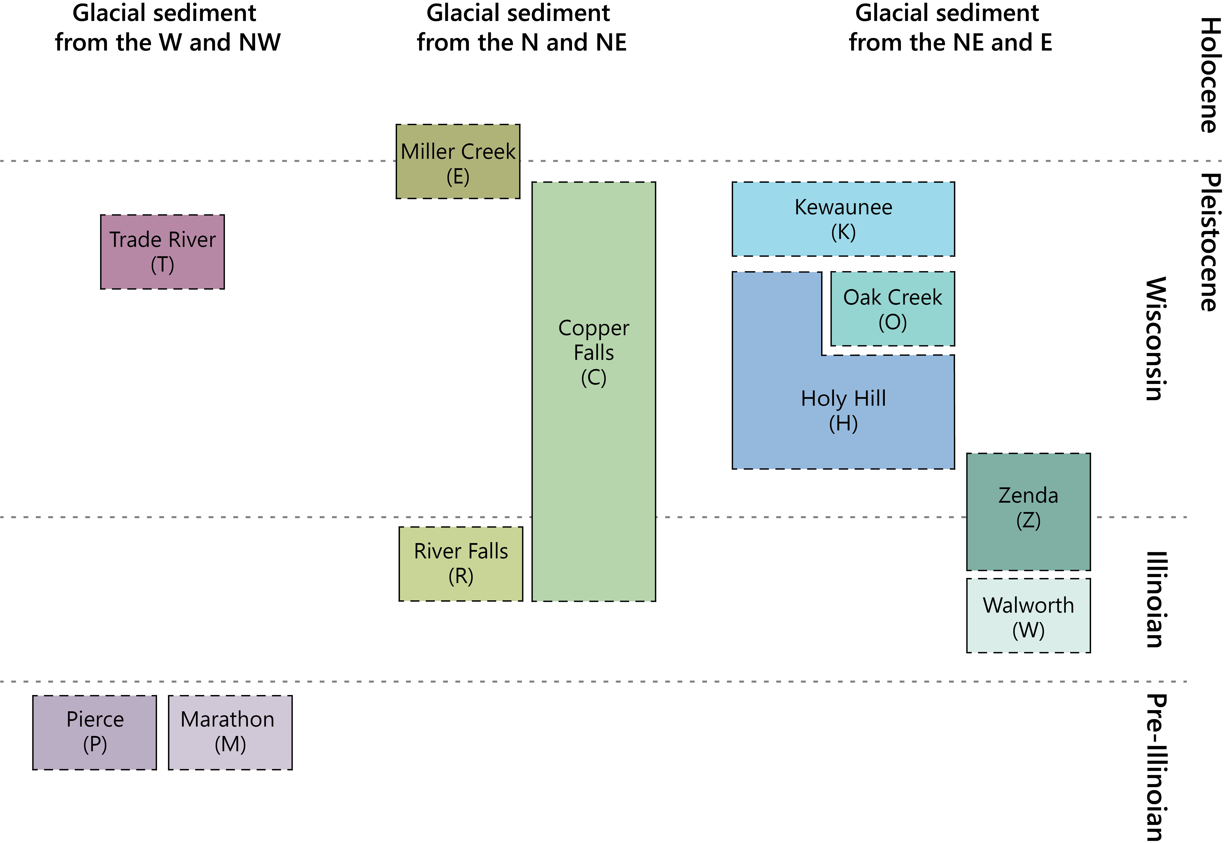
Illustration of the spatial and temporal distribution of mapped formations of glacial sediment (Syverson and others, 2011). Formations are represented in purple, green, and blue color groupings based on the sediment source area. The map on the left shows their distribution across Wisconsin. The schematic chart below shows their distribution through time, with oldest units at the bottom. In the chart, the [horizontal dashed lines] mark the boundaries between the Wisconsin, Illinoian, and Pre-Illinoian glacial periods of the Pleistocene epoch, and the onset of the current Holocene epoch approximately 11,700 years ago.
[CMU / Overview layer Map]
Instructions for the Please note that this will not work on mobile devices. In the interactive CMU Diagram below, use either button below to enter the diagram. Use the Escape key to exit the diagram. To navigate within, use arrow keys to explore nodes, use Enter key to drill in and Backspace key to drill out.
Stratigraphic Chart (multi-file demo)
Glacial History
Map of glacial lobes (below) depicts the late Wisconsin glacial lobes in Wisconsin and areas where sediments of Illinoian age (about 150,000 years ago) and pre-Illinoian age (before about 300,000 years ago) are found. The edge of named lobes indicates the edge of the late Wisconsin ice sheet. Two areas indicate major late Wisconsin readvances. Driftless Area was not glaciated during the Quaternary.
Methods and Sources
Methods
Geologic mapping was based on the study of published and unpublished WGNHS map data (sources below), 1.5-m resolution lidar-derived elevation and shaded relief models (State Cartographer's Office, 2023), and Soil Survey Geographic database (Soil Survey Staff, 2018). Lithostratigraphic usage follows that of Syverson and others (2011). Map unit contacts were drawn in a GIS software and generalized to a scale of 1:500,000.
Basemap data sources
Ice Age National Scenic Trail data from the Ice Age Trail Alliance (accessed 2023). North Country National Science Trail data from the North Country Trail Association (accessed 2024). Hydrologic data adapted by WGNHS from National Hydrography Dataset (accessed 2023). Highways, county and tribal boundaries, and county seats from the U.S. Geological Survey's The National Map and the Wisconsin State Tribal Relations Initiative (accessed 2023). Tribal seats from Wisconsin First Nations (2018). Ho-Chunk Nation boundaries from written communication (2024). Ceded territory boundaries from Great Lakes Indian Fish and Wildlife Commission (version 2.1, accessed 2024).
Principal Sources of Map Information
- Attig, J.W., 1985, Pleistocene geology of Vilas County, Wisconsin: Wisconsin Geological and Natural History Survey Information Circular 50, 32 p., 1 pl., scale 1:100,000, https://doi.org/10.54915/zued8033.
- Attig, J.W., and Muldoon, M.A., 1989, Pleistocene geology of Marathon County, Wisconsin: Wisconsin Geological and Natural History Survey Information Circular 65, 27 p., 1 pl., scale 1:100,000, https://doi.org/10.54915/zvgm5218.
- Attig, J.W., 1993, Pleistocene geology of Taylor County, Wisconsin: Wisconsin Geological and Natural History Survey Bulletin 90, 25 p., 1 pl., scale 1:100,000, https://doi.org/10.54915/gatd1076.
- Attig, J.W., and Ham, N.R, 1999, Quaternary geology of northern Oconto County, Wisconsin: Wisconsin Geological and Natural History Survey Bulletin 97, 13 p., 1 pl., scale 1:100,000, https://doi.org/10.54915/jfqm9429.
- Attig, J.W., and Batten, W.G., 2004, Quaternary geology of the Peshtigo River State Forest area: Wisconsin Geological and Natural History Survey Open-File Report 2004–05, 1 pl., scale 1:100,000, https://doi.org/10.54915/prty7117.
- Attig, J.W., and Rawling III, J.E., 2020, Quaternary geology of Oneida County, Wisconsin: Wisconsin Geological and Natural History Survey Map 507, 1 pl., scale 1:100,000, https://doi.org/10.54915/nuri4216.
- Batten, W.G., and Attig, J.W., 2010, Preliminary geology of Iowa County, Wisconsin: Wisconsin Geological and Natural History Survey Open-File Report 2010–01, 2 pls., scale 1:100,000, https://doi.org/10.54915/dekh8646.
- Carlson, A.E., Principato, S.M., Chapel, D.M., and Mickelson, D.M., 2011, Quaternary geology of Sheboygan County, Wisconsin: Wisconsin Geological and Natural History Survey Bulletin 106, 32 p., 2 pls., scale 1:100,000, https://doi.org/10.54915/byhi8565.
- Carson, E.C., 2012, Preliminary Quaternary geology of Grant County, Wisconsin: Wisconsin Geological and Natural History Survey Open-File Report 2012–06, 1 pl., scale 1:100,000, https://doi.org/10.54915/xdwu2747.
- Carson, E.C., Brown, S.C., Mickelson, D.M., and Schneider, A.F., 2016, Quaternary geology of Door County, Wisconsin: Wisconsin Geological and Natural History Survey Bulletin 109, 44 p., 1 pl., scale 1:100,000, https://doi.org/10.54915/tfkt2502.
- Clayton, L., 1984, Pleistocene geology of the Superior Region, Wisconsin: Wisconsin Geological and Natural History Survey Information Circular 46, 40 p., 1 pl., scale 1:250,000, https://doi.org/10.54915/fdmm3282.
- Clayton, L., 1986a, Pleistocene geology of Florence County, Wisconsin: Wisconsin Geological and Natural History Survey Information Circular 51, 13 p., 1 pl., scale 1:100,000, https://doi.org/10.54915/vxoj5593.
- Clayton, L., 1986b, Pleistocene geology of Portage County, Wisconsin: Wisconsin Geological and Natural History Survey Information Circular 56, 19 p., 2 pls., scale 1:100,000, https://doi.org/10.54915/hlhj8739.
- Clayton, L., 1987, Pleistocene geology of Adams County, Wisconsin: Wisconsin Geological and Natural History Survey Information Circular 59, 14 p., 2 pls., scale 1:100,000, https://doi.org/10.54915/fnqs2846.
- Clayton, L., 1989, Geology of Juneau County, Wisconsin: Wisconsin Geological and Natural History Survey Information Circular 66, 16 p., 2 pls., scale 1:100,000, https://doi.org/10.54915/pbhz3607.
- Clayton, L., 1991, Pleistocene geology of Wood County, Wisconsin: Wisconsin Geological and Natural History Survey Information Circular 68, 18 p., 2 pls., scale 1:100,000, https://doi.org/10.54915/jqjh5013.
- Clayton, L., 2001, Pleistocene geology of Waukesha County, Wisconsin: Wisconsin Geological and Natural History Survey Bulletin 99, 33 p., 2 pls., scale 1:100,000, https://doi.org/10.54915/wygl1991.
- Clayton, L., 2013, Pleistocene geology of Kewaunee County, Wisconsin: Wisconsin Geological and Natural History Survey Bulletin 104, 44 p., 1 pl., scale 1:100,000, https://doi.org/10.54915/bnzi7327.
- Clayton, L., and Attig, J.W., 1990, Geology of Sauk County, Wisconsin: Wisconsin Geological and Natural History Survey Information Circular 67, 68 p., 2 pls., scale 1:100,000, https://doi.org/10.54915/opsv9854.
- Clayton, L., and Attig, J.W., 1997, Pleistocene geology of Dane County, Wisconsin: Wisconsin Geological and Natural History Survey Bulletin 95, 64 p., 2 pls., scale 1:100,000, https://doi.org/10.54915/gnav2983.
- Evans, T.J., 2003, Geology of La Crosse County, Wisconsin: Wisconsin Geological and Natural History Survey Bulletin 101, 33 p., 1 pl., scale 1:100,000, https://doi.org/10.54915/iwoe3334.
- Ham, N.R., and Attig, J.W., 1997, Pleistocene geology of Lincoln County, Wisconsin: Wisconsin Geological and Natural History Survey Bulletin 93, 31 p., 1 pl., scale 1:100,000, https://doi.org/10.54915/xqkh9748.
- Ham, N.R., and Attig, J.W., 2004, Preliminary Pleistocene geologic map of Walworth County, Wisconsin: Wisconsin Geological and Natural History Survey Open-File Report 2004–08, 1 pl., scale 1:100,000, https://doi.org/10.54915/nikd4976.
- Hooyer, T.S., Attig, J.W., and Clayton, L. 2004, Preliminary Quaternary geologic map of the central Fox River Lowland, Wisconsin: Wisconsin Geological and Natural History Survey Open-File Report 2004–04, 1 pl., scale 1:100,000, https://doi.org/10.54915/qmgu4325.
- Hooyer, T.S., Mode, W.N., Clayton, L., and Attig, J.W., 2005, Preliminary Quaternary geologic map of the southern Fox River Lowland, Wisconsin: Wisconsin Geological and Natural History Survey Open-File Report 2005–03, 1 pl., scale 1:100,000, https://doi.org/10.54915/qusq9745.
- Hooyer, T.S., and Mode, W.N., 2007, Preliminary Quaternary geologic map of the northern Fox River Lowland, Wisconsin: Wisconsin Geological and Natural History Survey Open-File Report 2007–05, 1 pl., scale 1:100,000, https://doi.org/10.54915/rewh6487.
- Hooyer, T.S., and Mode, W.N., 2008, Quaternary geology of Winnebago County, Wisconsin: Wisconsin Geological and Natural History Survey Bulletin 105, 41 p., 2 pls., scale 1:100,000, https://doi.org/10.54915/xkxw8656.
- Hooyer, T.S., Mode, W.N., and Clayton, L., 2021, Quaternary geology of Columbia, Green Lake, and Marquette Counties, Wisconsin: Wisconsin Geological and Natural History Survey Bulletin 114, 38 p., 1 pl., scale 1:100,000, https://doi.org/10.54915/yvcs2603.
- Ives, L.R.W., and Rawling, J.E., III, 2022, Quaternary geology of Jefferson County, Wisconsin: Wisconsin Geological and Natural History Survey Bulletin 118, 34 p., 1 pl., scale 1:100,000, https://doi.org/10.54915/mlnc7835.
- Johnson, M.D., 1986, Pleistocene geology of Barron County, Wisconsin: Wisconsin Geological and Natural History Survey Information Circular 55, 42 p., 1 pl., scale 1:100,000, https://doi.org/10.54915/zdqf2229.
- Johnson, M.D., 2000, Pleistocene geology of Polk County, Wisconsin: Wisconsin Geological and Natural History Survey Bulletin 92, 70 p., 1 pl., scale 1:100,000, https://doi.org/10.54915/eoje5164.
- Kostka, S.J., Hinke, H.J., Mickelson, D.M., and Baker, R.W., 2004, Preliminary Quaternary geologic map of St. Croix County, Wisconsin: Wisconsin Geological and Natural History Survey Open-File Report 2004–22, 1 pl., scale 1:100,000, https://doi.org/10.54915/athc7807.
- Mickelson, D.M., and McCartney, M.C., 1979, Glacial geology of Dane County, Wisconsin, plate 1 in Mickelson, D.M., 1983, A guide to the glacial landscapes of Dane County: Wisconsin Geological and Natural History Survey Field Trip Guide Book 6, 1 pl., scale 1:100,000, https://doi.org/10.54915/hmnt2279.
- Mickelson, D.M., 1986, Glacial and related deposits of Langlade County, Wisconsin: Wisconsin Geological and Natural History Survey Information Circular 52, 30 p., 1 pl., scale 1:100,000, https://doi.org/10.54915/npsx6860.
- Mickelson, D.M., and Syverson, K.M., 1997, Quaternary geology of Ozaukee and Washington counties, Wisconsin: Wisconsin Geological and Natural History Survey Bulletin 91, 56 p., 2 pls., scale 1:100,000, https://doi.org/10.54915/qwwg3089.
- Mickelson, D.M., and Socha, B.J., 2017, Quaternary geology of Calumet and Manitowoc counties, Wisconsin: Wisconsin Geological and Natural History Survey Bulletin 108, 60 p., 2 pls., scale 1:100,000, https://doi.org/10.54915/cmxk6837.
- Mode, W.M., Hooyer, T.S., Clayton, L., and Rawling, J.E., III, 2023, Quaternary geology of Waupaca County, Wisconsin: Wisconsin Geological and Natural History Survey Open-File Report Map 509, 8 p., 1 pl., scale 1:100,000, https://doi.org/10.54915/bger3320.
- Mode, W.N., Hooyer, T.S., and Rawling III, J.E., 2021, Quaternary geology of Fond du Lac County, Wisconsin: Wisconsin Geological and Natural History Survey Bulletin 116, 19 p., 1 pl., scale 1:100,000, https://doi.org/10.54915/kaqw7995.
- Need, E.A., 1985, Pleistocene geology of Brown County, Wisconsin: Wisconsin Geological and Natural History Survey Information Circular 48, 19 p., 1 pl., scale 1:100,000, https://doi.org/10.54915/rodj8221.
- Simpkins, W.W., McCartney, M.C., and Mickelson, D.M., 1987, Pleistocene geology of Forest County, Wisconsin: Wisconsin Geological and Natural History Survey Information Circular 61, 21 p., 1 pl., scale 1:100,000, https://doi.org/10.54915/bgos7036.
- Syverson, K.M., 2007, Pleistocene geology of Chippewa County, Wisconsin: Wisconsin Geological and Natural History Survey Bulletin 103, 53 p., 2 pls., scale 1:100,000, https://doi.org/10.54915/nfyy5661.
- Thwaites, F.T., 1943, Pleistocene of part of northeastern Wisconsin: Geological Society of America Bulletin, v. 54, no. 1, p. 87–144, 1 pl., scale 1:250,000, https://doi.org/10.1130/GSAB-54-87.
Other Sources of Map Information
- Alden, W.C., 1918, The Quaternary geology of southeastern Wisconsin, with a chapter on the older rock formations: U.S. Geological Survey Professional Paper 106, 356 p., 4 pls., scale 1:250,000, https://doi.org/10.3133/pp106.
- Chamberlin, T.C., 1881, General map of the Quaternary formations of Wisconsin, plate 2 of Atlas of the Geological Survey of Wisconsin: Madison, Wis., Wisconsin Geological Survey, 1 pl., scale approximately 1:960,000.
- Martin, L., 1932, The physical geography of Wisconsin (2d ed): Wisconsin Geological and Natural History Survey Bulletin 36, 608 p., https://doi.org/10.54915/ojgk6416.
- State Cartographer's Office, 2023, Wisconsin elevation/lidar data, accessed December 1, 2020 at https://www.sco.wisc.edu/data/elevationlidar/.
- Soil Survey Staff, 2018, Web Soil Survey: Natural Resources Conservation Service, U.S. Department of Agriculture, accessed 2018 at https://websoilsurvey.sc.egov.usda.gov/.
- Syverson, K.M., Clayton, L., Attig, J.W., and Mickelson, D.M., eds., 2011, Lexicon of Pleistocene stratigraphic units of Wisconsin: Wisconsin Geological and Natural History Survey Technical Report 1, 180 p., https://doi.org/10.54915/xbyw7762.
- Syverson, K.M., and Colgan, P.M., 2011, The Quaternary of Wisconsin: an updated review of stratigraphy, glacial history and landforms, in Ehlers, J., Gibbard, P.L., and Hughes, P.D., eds., Quaternary glaciations—Extent and chronology: a closer look: Amsterdam, Elsevier, Developments in Quaternary science, v. 15, p. 537–552, https://doi.org/10.1016/B978-0-444-53447-7.00042-8.
- Thwaites, F.T., 1956, Glacial features of Wisconsin: Wisconsin Geological and Natural History Survey M032, 1 pl., scale 1:500,000, https://doi.org/10.54915/clfb1435.
- Thwaites, F.T., and Bertrand, K., 1957, Pleistocene geology of the Door Peninsula, Wisconsin: Geological Society of America Bulletin, v. 68, no. 7, p. 831–880, 1 pl., scale 1:250,000, https://doi.org/10.1130/0016-7606(1957)68[831:PGOTDP]2.0.CO;2.
- Weidman, S., 1907, The Geology of north central Wisconsin: Wisconsin Geological and Natural History Survey Bulletin 16, 697 p., 3 pls., scale 1:200,000, https://doi.org/10.54915/xspo5249.
- Wisconsin First Nations, 2018, Current tribal lands map and native nations facts: Wisconsin First Nations, 1 pl., scale 1:1,001,739, https://wisconsinfirstnations.org/current-tribal-lands-map-native-nations-facts/.
Downloads
Our publications catalog offers two downloads related to this publication: a PDF file of the print poster layout and a zipped folder containing GIS data. Both can be found at this link: https://wgnhs.wisc.edu/catalog/publication/001011
.